Cycling News & Blog Articles
New renderings show what expanded I-5 could look like in Vancouver
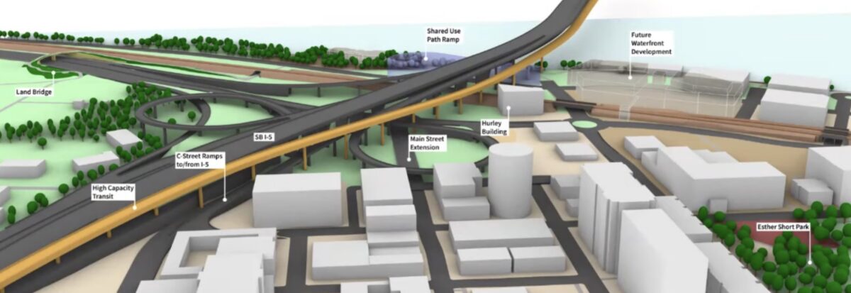
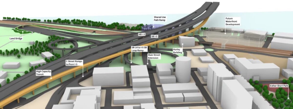
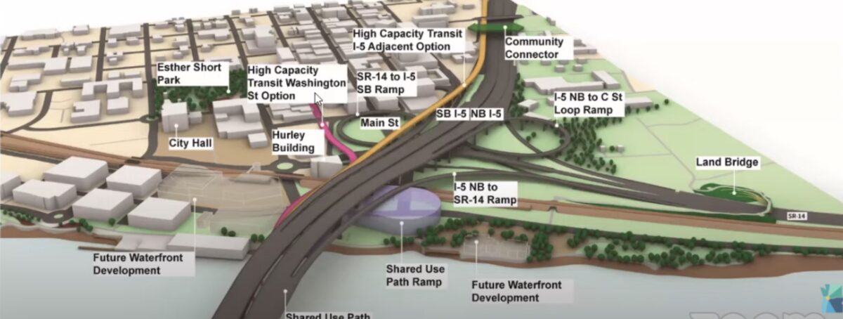
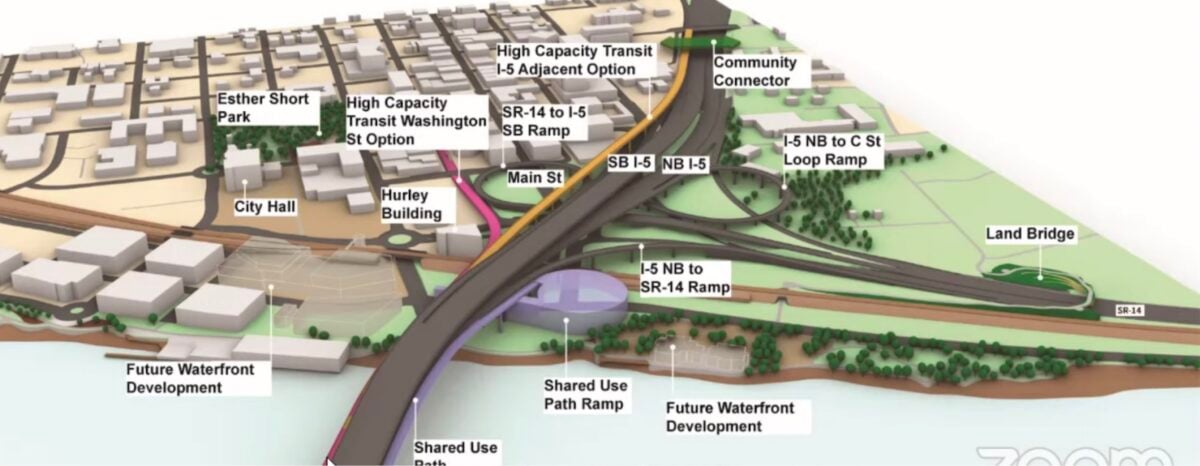
Views of concepts looking northwest toward downtown Vancouver from the Columbia River.
(Source: Interstate Bridge Replacement Program)
Elected officials working on the expansion of Interstate 5 between Oregon and Washington this week got a look at early renderings (more below) of the narrow set of options for the new highway, focused around downtown Vancouver.
“I know the moment this is shared, social media and everybody else is going to want to publish all of this information.”
— Anne McEnerny-Ogle, Vancouver Mayor
These renderings weren’t available in advance of the Interstate Bridge Replacement Program (IBR) Executive Steering Group’s Thursday meeting and as of the time of publication still had not been posted, suggesting they are being held close to the vest. During the meeting, the group discussed the possibility of the images being taken out of context, with one member suggesting they come with a disclaimer. “I know the moment this is shared, social media and everybody else is going to want to publish all of this information. We know it’s very high level, we know it’s conceptual, we want to make sure it doesn’t represent any decisions that are being made, that we are working toward that process,” Anne McEnerny-Ogle, Vancouver Mayor said.
Program administrator Greg Johnson noted that the designs were “still in the talking stages” but that they were being shared with groups like the Cowlitz Tribe to get their feedback on the project’s impact on Fort Vancouver.
Shown were the two major choices for the ten-lane highway: two bridges side-by-side or stacked on top of each other. Both loom over downtown Vancouver. What they don’t show is how the new highway would look to someone at ground level in Vancouver’s growing downtown.
The renderings won’t surprise anyone who has seen the proposals developed for the Columbia River Crossing a decade ago, but reiterate what a major impact a new elevated ten-lane highway would make in Vancouver.
Advertisement

Rendering from 2007 showing the Columbia River Crossing project from downtown Vancouver. (Source: WSDOT)
Moments after these renderings were shared on Twitter Thursday while the meeting was taking place, the IBR team sent a statement attributed to Greg Johnson to ensure that they were not taken out of context. “It is important to note that the new visualizations feature more detail than what has been shown previously, but do not represent new options created for this exercise. These are intended to provide a 3-D illustration at a high level and are not representative of specific property impacts. As you know, we are still in the process of evaluating design options and determining which option may move forward to be incorporated into the IBR solution, with more design detail to be added as we are farther in the process,” the statement read.
The project team is still working on models that look at what influence high levels of demand management and transit investments could have on the three proposed designs for the highway, but we haven’t seen the results of that even as we start to see conceptual renderings.
Not shown was any rendering of what the highway might look like on Hayden Island. A decade ago, Hayden Island was set to see the biggest impact from the Columbia River Crossing, with a significant number of properties permanently acquired for the project (shown in red below).
Advertisement
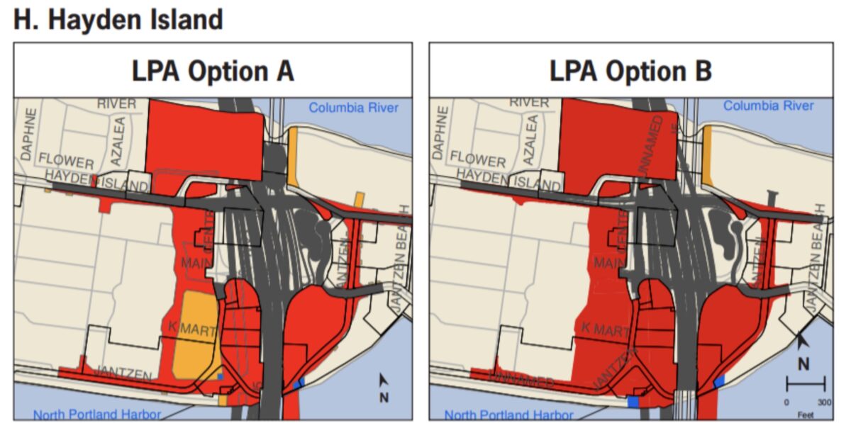
Property acquisition and highway footprint on Hayden Island, from the Columbia River Crossing’s Final Environmental Impact Statement.
In December, the Hayden Island Neighborhood Network (HINooN) approved a resolution supporting a “no build” option for the IBR project, instead pushing for a third bridge over the Columbia River. Their resolution noted that the project was heading down the exact same path as the CRC.
“What is happening does not feel like equity for us at all. We are against the massive intrusion over the island.”
— Jan Roxburgh, Hayden Island resident
Hayden Island resident Jan Roxburgh is one of many who don’t support the current project. “What is happening does not feel like equity for us at all. More like further traumatizing,” she shared with us via email this week. “Our community would be destroyed by what IBRP proposes. It is like the CRC just being regurgitated. It seems unreal that this same old story is being played out now in the light of more knowledge available about the dangers that are presented by climate change.”
“We are against the massive intrusion over the island,” Roxburgh continued. “Their plan is a massive freeway footprint over the island. What do we get in exchange for all this destruction? We get to save a minute and a half off our commute time during rush hour. The promise to climate change and equity are only empty words on paper.”
The project team is currently in a race to get a modified Locally Preferred Alternative (LPA) selected by this summer, even as it looks like the Washington legislature may not appropriate any construction funding for the IBR until 2023. Last week, President Joe Biden listed the project as one of the most “economically significant bridges” in the country, a mention that Greg Johnson said put “wind in our sails” as they work to design the new highway.
On the heels of the Oregon Department of Transportation receiving word that the Federal Highway Administration has rescinded the Finding of No Significant Impact for the Rose Quarter highway expansion project and is requiring more environmental review of that project, the IBR is seeking to get through the federal environmental approval process as quickly as possible.
![]()
Contributor Ryan Packer lives in Seattle and covers transportation issues as a Senior Editor at The Urbanist. This past winter they held a four-month temporary post as the editor of the Seattle Bike Blog. Contact them at This email address is being protected from spambots. You need JavaScript enabled to view it..

